
Trail Surface: Paved
-
-
Kum Bay Xerel
Read More -
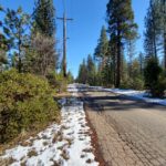
Mountain View Road
3 miles round trip; paved, no sidewalks. Mountain View Road to the water tower. This trail is a walk in the woods close to town. From Safeway, turn south at the traffic light onto Mountain View Road. Continue past historic Burney Cemetery, local …
Read More -
Northeast Crossing Trail
Connects to a neighborhood park, shopping, Turtle Bay, and downtown Redding. NorthEast Crossing Trail Opens! #ConnectOurCity | Shasta Living Streets
Read More -
Redding Rancheria Trail
Read More -
Lower Sacramento Rail Trail
Trail Guide with elevation profiles, photos and details for walking a 2.5 mile loop featuring the dirt Fisherman's Trail Loop: Trail Guide from Trails & Bikeways Council
Read More -
Middle Creek Trail
Read More -
Upper Sacramento Rail Trail
Detailed information and photos: Trail Guide from Trails & Bikeways Council
Read More -
Sacramento River Trail
Read More -
Walk Burney
Read More -
City Hall Area & Sculpture Park
The Sculpture Park | Facility Directory Table List | City of Redding Also, enjoy the Parkview Neighborhood Spheres Walk in the Redding Walks Guide.
Read More -
Clover Creek Preserve
Read More -
Lema Ranch Trails
Additional information at The McConnell Foundation
Read More -
Margaret Polf Park
Walk the City of Shasta Lake Shasta-Lake-Walks_website.pdf (healthyshasta.org)
Read More -
Blue Gravel Mine Trail
Read More -
Arboretum Loop Trail
Read More